
The weather forecast can get extreme in the land of Hyrule, found in the Nintendo series The Legend of Zelda. A downpour in the coastal province of Faron, for instance, prevents Link, the game’s hero, from reaching Calora Lake. And constant lightning and rain threaten the skybound Thunderhead Isles. These storms only end once Link completes a series of quests, all while dodging lightning.
Never-ending storms make for moody gameplay. But real storms “can’t last forever,” says Stephanie Spera. Storms result from imbalances between moisture and temperature. “A storm kind of fixes a temporary imbalance,” she says. This physical geographer at the University of Richmond in Virginia uses satellite data to study changes to the landscape.
“The whole purpose of anything in weather is to get the atmosphere back in balance,” explains Chris Vagasky. He directs the Wisconsin Environmental Mesonet. It’s a network of weather stations. Physical features such as mountains and oceans, even buildings, often keep that from happening, he says. Though violent at times, thunderstorms help balance and redistribute heat, moisture and electrical charges.
For constant thunderstorms like those seen in Faron, those imbalances would have to remain out of whack. But on Earth, atmospheric physics ensures that even the strongest storms eventually fade away.
No storm lasts forever
Thunderstorms form when warm, moist air rapidly rises and meets cooler air in the atmosphere. This creates the instability needed for a storm. Such moisture often comes from the evaporation of ocean water. As this moisture-filled, warm air rises, it creates updrafts — upward air movements. Water vapor in this air condenses into droplets, forming a cumulus cloud. This cloud formation, in turn, releases energy as heat. That heat fuels stronger updrafts, which power the storm.
Within the clouds, water droplets collide with ice crystals. This creates static charges and, in turn, lightning. As a cloud grows, water droplets become heavy enough to fall through it. The resulting rain and ice create cooler downward winds, or downdrafts. They cool the cloud and eventually overpower the warmer updrafts. As the atmosphere now regains its balance, the storm ends.
Most thunderstorms only last an hour at most. For constant thunderstorms, such as those seen in Faron, you’d need to maximize a storm’s ingredients, says Vagasky. For moisture, there would need to be a “persistent conveyor belt of warm, moist air.” This air would most likely be heated by 24-hour sunlight. And the Thunderhead Isles would likely need to hug mountains that could help condense that moist air into clouds.
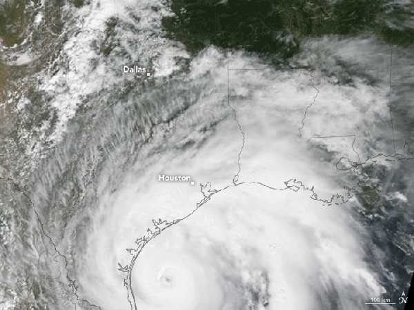 In 2017, Hurricane Harvey stalled over Houston, Texas, for about four days. During that time, some areas received more than 127 centimeters (50 inches) of rain.Jesse Allen/NASA
Keeping things moving
Even if a storm could sustain its own internal energy, it couldn’t stay in the same place forever. That’s because Earth’s atmosphere is in constant motion. Large belts of wind blow in particular directions (based on their latitude). Some storms get an extra boost from fast, narrow bands of wind called jet streams. Like conveyor belts, these streams move weather across continents. Clocking in at up to 320 kilometers (200 miles) per hour, jet streams “really help to push all of that activity from one place to another,” Vagasky says.
Sometimes these wind patterns can increase how long storms last. High-pressure systems or the jet stream can make Earth’s longest-lasting storms — tropical cyclones — sort of stall out in one place for a bit. In August 2017, for instance, weak prevailing winds let two high-pressure systems hover over the United States. In turn, Hurricane Harvey stalled over Houston, Texas, for about four days. Fueled by warm coastal waters, some areas received more than 127 centimeters (50 inches) of rain before the storm moved inland and broke up.
Like Houston, Faron lies along a coast. Depending on where Hyrule is located on the planet, it may be at risk for cyclones. But a cyclone couldn’t last year-round unless the oceans stayed consistently warm. On Earth, cyclones die when they make landfall, face windshear or reach colder water in higher latitudes. “They need to be refueled, which is why they die over land,” says Spera. “There’s no energy source.”
Learn about the basic ingredients of every thunderstorm and how weather satellites watch for developing storms.Earth’s flashiest storms
Thanks to physics, perpetual storms like those in Faron are impossible on Earth. But certain scenarios come close.
The storm plaguing the Thunderhead Isles looks similar to a region called the Intertropical Convergence Zone (ITCZ), says Spera. This solid band of clouds encircles the globe near the equator. Here, prevailing winds from the northern and southern hemispheres meet. This lifts warm, humid air heated by the intense sunlight found in the tropics.
But the ITCZ isn’t a single, massive thunderstorm, Spera adds. Instead, a series of intense but short-lived events develop here. This zone also moves back and forth across the equator, leading to seasonal monsoon rains like those found on the Indian subcontinent. If the Thunderhead Isles were under the ITCZ, they wouldn’t have the relentless lightning storms seen in The Legend of Zelda games. Instead, it would just “be really rainy for a really long time.”
For flashier storms, the Catatumbo lightning phenomenon is truly unrivaled. This mass of thunderstorms occurs over Lake Maracaibo in coastal Venezuela. Here, lightning flashes up to 300 days per year and can last for nine hours at a stretch! Catatumbo holds the world’s record for the most concentrated lightning.
The key to Catatumbo lightning is geography. The nearby Caribbean Sea offers huge amounts of warm, humid air. Lake Maracaibo sends in added moisture. Winds whisk this moist air up the northern end of the Andes Mountains. There it meets colder air. The bowl-shaped mountains hugging the lake prevent the resulting cumulonimbus clouds from moving. This can lead to stagnant thunderstorms, ones similar to those of the Thunderhead Isles. Says Vagasky, “Catatumbo is one of the closest things that we might see to that.”


 Bengali (Bangladesh) ·
  English (United States) ·